http://www.ebay.com/itm/1969-POSTER-Zionist-MAP-Jewish-ISRAEL-vs-ARABS-M...
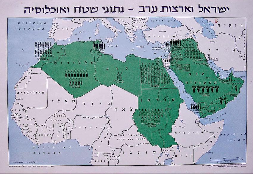
DESCRIPTION : Here for sale is a genuine authentic RARE vintage around 45 years old ZIONIST POLITICAL POSTER including the illustrated MAP of ISRAEL compared to those of its ARAB - MUSLIM neighbours . It was issued by the ISRAELI GOVERNMENT in ca 1969 after the SIX DAYS WAR for the purpose of demontraiting and presenting the IMMENSE difference both in population as well as in size between ISRAEL and its ARAB - MUSLIM neighbours . In ca 1967 , The number of Israeli Jews was 2,345,000inhabitants , While the size ( Still including the HUGE Sinai desert which was returned o the Egyptians as a part of the peace process with Egypt and still including the Gaza strip which was returned to the Palestins ) was 90,000 square kilometers. NOWDAYS actual size is only 20,700 !!! square kilometers. While the figures of all the Arab - Muslims countries at the time ( Excluding IRAN which at the time , Before the current fanating regime , In diplomatic relations and friendly peace with Israel ) are , Total population of104,000,000 inhabitants , And ( And it's not an arithmetic mistake.....) size of 12,195,000 square kilometers. An EXTREMELY IMPORTANT MAP which should be re-printed and dispatched WORLDWIDE . The HEBREW heading is " ISRAEL AND THE ARAB COUNTRIES - DATA OF POPULATION AND SIZE". The poster SIZE is around 13.5" x 19.5" ( Not accurate ) . The poster is printed on white paper . Excellent pristine condition. Unfolded ( Pls look at scan for accurate AS IS images ) The POSTER will be sent in a special protective rigid sealed envelope .